 |
|||||||||||||
|
Class Projects | ||||||||||||||||||||||||||||||||||||||||||||||||||||||||||||||||||||||||||||||||||||||||||||||||||||||||||||||||||||||||||||||||||||||||||||||||||||||||||||||||||||||||||||||||||||||||||||||||||||||||||||||||||||||||||||||||||||||||||||||||
Terrill Yazzie, Rio Grande Project, 3/3/2012 | ||||||||||||||||||||||||||||||||||||||||||||||||||||||||||||||||||||||||||||||||||||||||||||||||||||||||||||||||||||||||||||||||||||||||||||||||||||||||||||||||||||||||||||||||||||||||||||||||||||||||||||||||||||||||||||||||||||||||||||||||
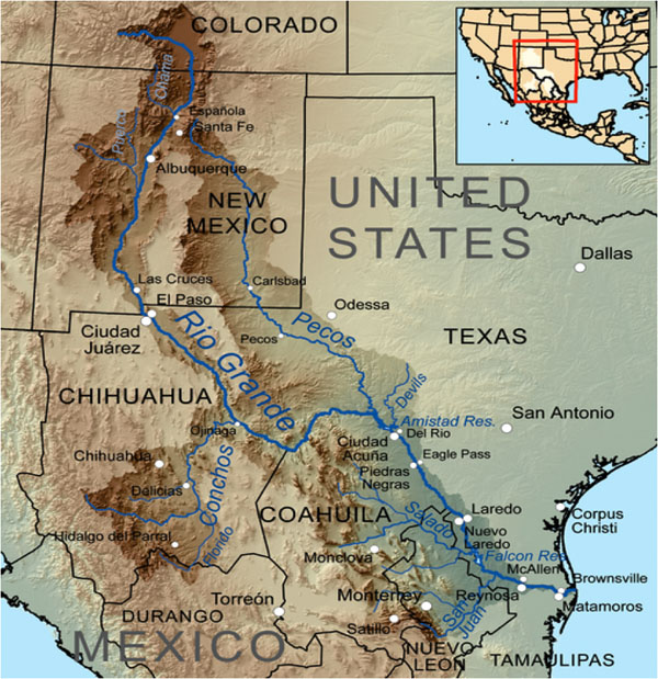
| Problem: How do we conserve the Rio Grande?
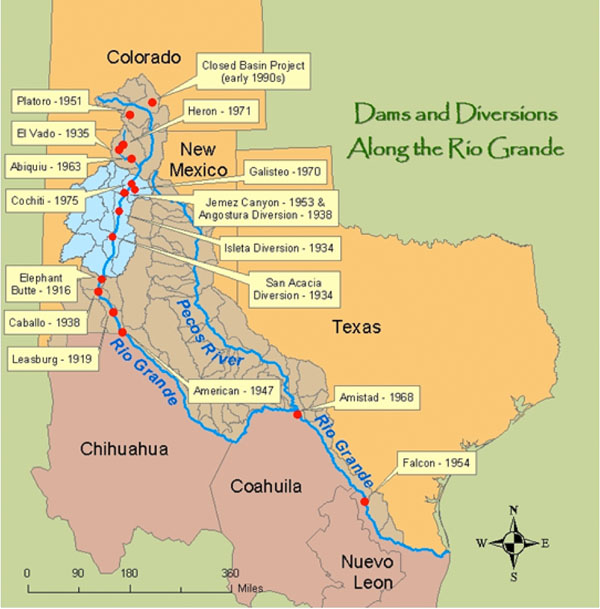
The problem area: see map. | ||||||||||||||||||||||||||||||||||||||||||||||||||||||||||||||||||||||||||||||||||||||||||||||||||||||||||||||||||||||||||||||||||||||||||||||||||||||||||||||||||||||||||||||||||||||||||||||||||||||||||||||||||||||||||||||||||||||||||||||||
 | ||||||||||||||||||||||||||||||||||||||||||||||||||||||||||||||||||||||||||||||||||||||||||||||||||||||||||||||||||||||||||||||||||||||||||||||||||||||||||||||||||||||||||||||||||||||||||||||||||||||||||||||||||||||||||||||||||||||||||||||||
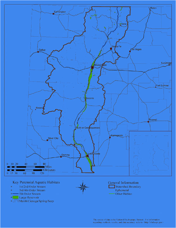 | ||||||||||||||||||||||||||||||||||||||||||||||||||||||||||||||||||||||||||||||||||||||||||||||||||||||||||||||||||||||||||||||||||||||||||||||||||||||||||||||||||||||||||||||||||||||||||||||||||||||||||||||||||||||||||||||||||||||||||||||||
| The problem of the Rio Grande can extend to more than just the river itself and local terrestrial banks. A geological aspect may add to the problem. | ||||||||||||||||||||||||||||||||||||||||||||||||||||||||||||||||||||||||||||||||||||||||||||||||||||||||||||||||||||||||||||||||||||||||||||||||||||||||||||||||||||||||||||||||||||||||||||||||||||||||||||||||||||||||||||||||||||||||||||||||
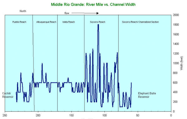 | ||||||||||||||||||||||||||||||||||||||||||||||||||||||||||||||||||||||||||||||||||||||||||||||||||||||||||||||||||||||||||||||||||||||||||||||||||||||||||||||||||||||||||||||||||||||||||||||||||||||||||||||||||||||||||||||||||||||||||||||||
| The greatest channel width is at river mile 110. Why?
There are problems with sediment, reduction in peak spring run-off flows, armoring of banks and point bars, and establishment of non native phreatophyte forests. The current condition greatly favors non-native, water consuming, phreatophyte species. Additionally, certain segments of the Socorro Reach are experiencing a depravity of sediment, while others (south of Bosque Del Apache NWR) are experiencing excessive sedimentation problems. Please see Technical Memorandum from The Bosque Hydrology Group. Phreatophytes have biological value as being used as biofilters. They are plants of great ecological value, fast growing pioneers and highly resistant to disease. They make excellent fodder for livestock and provide nesting areas and shelter for fauna. They are used as fuel, cheap construction material, and basketry. Many of the plants grow in degraded waters, salty or saline, that are useless for agriculture. Phreatophyte plants help to purify these waters and their roots fix heavy metals with a bacteria filter. Thoughts
| ||||||||||||||||||||||||||||||||||||||||||||||||||||||||||||||||||||||||||||||||||||||||||||||||||||||||||||||||||||||||||||||||||||||||||||||||||||||||||||||||||||||||||||||||||||||||||||||||||||||||||||||||||||||||||||||||||||||||||||||||
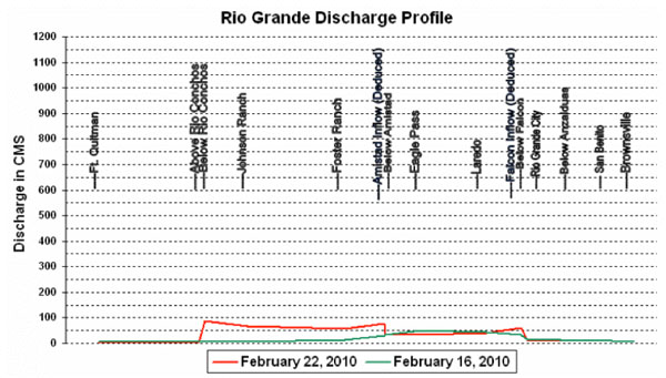 | ||||||||||||||||||||||||||||||||||||||||||||||||||||||||||||||||||||||||||||||||||||||||||||||||||||||||||||||||||||||||||||||||||||||||||||||||||||||||||||||||||||||||||||||||||||||||||||||||||||||||||||||||||||||||||||||||||||||||||||||||
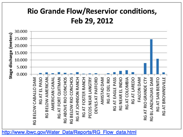
This Graph shows discharge in the southern part of the river in Texas/Mexico. Thoughts
Invasive plants
Please see Tamarisk info. Arthropods
Birds
Amphibian
Fish
Please see New Mexico Museum of Natural Science and History. Table 2
Based on the data given here, the ratio of native fish to non-native in the MRG is 40%, the LRG canal is 28%, and the LRG Drain Canals is 32%. Attacking the problems of maintaining native fish populations to substantiate the Rio Grande could be addressed by a plan to increase LRG native fish population, and the solution could positively impact the LRG Drain canals. Dams
Please see Technical Memorandum from The Bosque Hydrology Group. Data about the reservoirs show that Falcon, Elephant Butte, and Caballo are increasing in storage capacity. Amistad is the only one declining with use. Please see Rio Grande Reservoir Storage Conditions. Questions: What factors are affecting Amistad decline? Maps of the Dams on the Rio Grande | ||||||||||||||||||||||||||||||||||||||||||||||||||||||||||||||||||||||||||||||||||||||||||||||||||||||||||||||||||||||||||||||||||||||||||||||||||||||||||||||||||||||||||||||||||||||||||||||||||||||||||||||||||||||||||||||||||||||||||||||||
 | ||||||||||||||||||||||||||||||||||||||||||||||||||||||||||||||||||||||||||||||||||||||||||||||||||||||||||||||||||||||||||||||||||||||||||||||||||||||||||||||||||||||||||||||||||||||||||||||||||||||||||||||||||||||||||||||||||||||||||||||||
 | ||||||||||||||||||||||||||||||||||||||||||||||||||||||||||||||||||||||||||||||||||||||||||||||||||||||||||||||||||||||||||||||||||||||||||||||||||||||||||||||||||||||||||||||||||||||||||||||||||||||||||||||||||||||||||||||||||||||||||||||||
|
Please see Rio Grande Basin Conditions. How fast is the bank increasing? Pollution Human induced problems include agriculture, pumpage, mining, and urbanization. Irrigation Channels Problems Irregular Shapes - Landscapes are often designed with many irregular shapes that do not match the options available for sprinkler head patterns. Although those shapes can be quite attractive, they result in inefficient use of water through over-spray onto fences, rocks, etc. Soil Conditions - Poor top soil, deficient in organic material or severely compacted causes many lawn problems including a shorter lifetime for your lawn. Often these lawns look good at first year but the roots do not develop well and there is poor percolation and drainage. Soil amendments are available as well as aeration, and thatching. Sometimes it is best to start over with good topsoil. Shade or Full Sun - How much water your plants need is greatly affected by how warm the air is around them. Areas in full sun will need more water than otherwise calculated --- areas with significant shade will need less. If either of these conditions exist, adjust your watering volumes as appropriate. Mowing Frequency and Height of Lawn - A shorter lawn will need more water than one with taller grass since the taller grass helps shade the roots and keep the moisture in. Back Flow Preventers - A back flow preventer is essential to protect your inside water for cooking and washing from contamination with outside water in the event of a sudden change in water pressure. Old or Broken Irrigation Systems - Problems with older systems include:
New Technologies Sprinkler Heads - Traditional sprinkler heads deliver water fast (1.5"/hr). Two traditional problems: (1) The ground can only absorb water at the rate of .3" - .5"/hr. (2) Misting due to fine spray. Newer heads pop-up, but have multi-stream rotors rather than thin spray and they provide slow watering (.4"/hr.) to match the absorption rate of your lawns soil. These heads are pressure matched to deliver water with greater uniformity than traditional heads (efficiency of about 80% vs. 70%). The WUA offers rebates for these new multi-stream heads. Controllers (timers) - New generation has many more options, easier to program and can add rain sensors.
The Nomenclature of Irrigation Canals in New Mexico Canal Type Other Names in Use Purpose Canal aka Main canal, lateral, ditch. Purpose: Deliver water from the acequia, acequia madre, Rio Grande to water users conveyance canal Drain aka canal Drain, clear ditch Drain Purpose: excess water from fields; prevent waterlogging of soils by intercepting shallow groundwater; provide flood protection Return canal aka Waste way Purpose: Return water from the irrigation system to the Rio Grande Study by Sallenave et al states that the study indicated that irrigation
canals are great refugee for fish during drying periods.
Quality of Water Non-point sources such as increase of septic tanks, residual minerals from evapo-transpiration, urban run-off, and wide spread application agricultural chemicals. Point sources are oil and gas reservoirs both natural and manmade that leak, metal and minerals from mining and milling, nitrate from dairies, sewage treatment plant, explosive manufacturing, other industrial facilities, septic tanks, and landfills. Please see Rio Grande Valley Study at USGS. Aquifers Most of the precipitation that falls in the valleys is lost to evaporation and transpiration, and little water percolates to a depth sufficient to recharge the basin-fill aquifers. The rate of precipitation recharge is affected by many factors, including quantity and duration of precipitation, soil-moisture content, rate of evapotranspiration, topography, soil permeability, and depth to ground water. Estimated rates of precipitation recharge are essentially zero in areas subject to a combination of little precipitation, substantial evapotranspiration, steep land surface, relatively impermeable soil, and deep water table. In a few areas, primarily in stream valleys with highly permeable soil and shallow depth to water, precipitation recharge may exceed 0.2 inch per year. Please see Aquifer Basics at USGS. | ||||||||||||||||||||||||||||||||||||||||||||||||||||||||||||||||||||||||||||||||||||||||||||||||||||||||||||||||||||||||||||||||||||||||||||||||||||||||||||||||||||||||||||||||||||||||||||||||||||||||||||||||||||||||||||||||||||||||||||||||
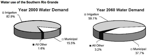 | ||||||||||||||||||||||||||||||||||||||||||||||||||||||||||||||||||||||||||||||||||||||||||||||||||||||||||||||||||||||||||||||||||||||||||||||||||||||||||||||||||||||||||||||||||||||||||||||||||||||||||||||||||||||||||||||||||||||||||||||||
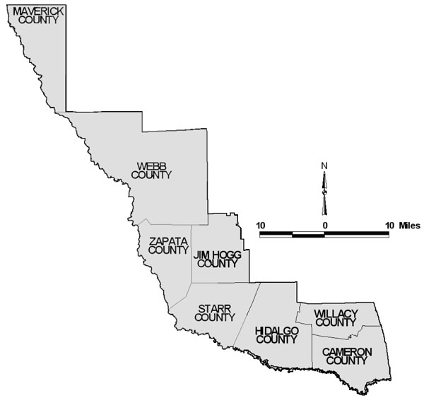
Why is Municipal going to increase? That growth in population will fuel increased demand for water for municipal purposes: drinking, hygiene, lawns and gardens, recreational use, etc. Municipal water demand, now about 230,000 acrefeet per year (AF/yr), is projected to swell to almost 626,000 AF/yr. (An acre-foot of water equals 325,581 gallons.) The vast majority of the water available to the region - more than 94 percent - comes from supplies stored in the Amistad and Falcon reservoir system. The Texas Water Development Board has estimated that unmet water needs could have considerable socioeconomic impacts on region: more than $2 billion lost to decreased sales, $2 billion in lost income, more than 26,000 lost jobs, and more than $75 million in lost taxes by 2060. Please see the document from the Rio Grande Regional Water Planning Group. Problem county areas along the Rio Grande | ||||||||||||||||||||||||||||||||||||||||||||||||||||||||||||||||||||||||||||||||||||||||||||||||||||||||||||||||||||||||||||||||||||||||||||||||||||||||||||||||||||||||||||||||||||||||||||||||||||||||||||||||||||||||||||||||||||||||||||||||
 | ||||||||||||||||||||||||||||||||||||||||||||||||||||||||||||||||||||||||||||||||||||||||||||||||||||||||||||||||||||||||||||||||||||||||||||||||||||||||||||||||||||||||||||||||||||||||||||||||||||||||||||||||||||||||||||||||||||||||||||||||
| Proposed Solutions to Conserving the southern Rio Grande:
(In progress) | ||||||||||||||||||||||||||||||||||||||||||||||||||||||||||||||||||||||||||||||||||||||||||||||||||||||||||||||||||||||||||||||||||||||||||||||||||||||||||||||||||||||||||||||||||||||||||||||||||||||||||||||||||||||||||||||||||||||||||||||||